Remote sources are contacted directly by your browser; EditPolygon does not proxy them.
Understand the remote-data boundary
Local files and remote services follow different network paths. Local GIS files remain inside the browser. When you deliberately add a remote source, your browser contacts that provider directly to discover, import or display the requested data. EditPolygon does not proxy the request through its own geoprocessing server.
A local layer can be edited without uploading it. A remote ArcGIS, GeoJSON, WMS or tile source necessarily reveals a normal browser request to that source provider when you use it.
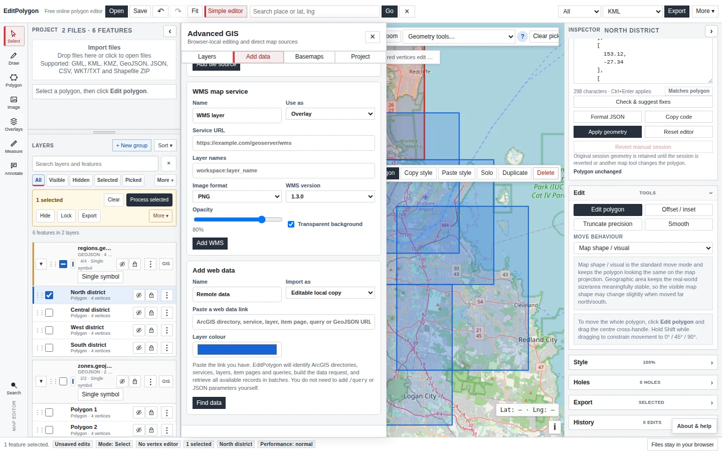
Open Advanced GIS → Add data
Switch to Advanced GIS and choose Add data. The panel separates local browser files from web sources and raster/tile services.
Use Open GIS files for local GeoJSON, KML/KMZ, GML, GeoPackage, Shapefile ZIP, zipped File Geodatabase, CSV, WKT, TopoJSON and project files. Use the remote sections only when the source is a web address or service.
Discover ArcGIS REST sources
EditPolygon understands common ArcGIS URLs rather than requiring you to manually construct a /query request. You can paste a services directory, FeatureServer/MapServer service, individual layer, query URL or supported ArcGIS item link.
The discovery flow can step through:
- Paste the ArcGIS link.
EditPolygon classifies the address and requests metadata directly from the provider.
- Choose a service or folder.
A REST services directory can contain many services.
- Choose one or more layers.
A FeatureServer/MapServer can expose several feature layers.
- Preview a selected layer where useful.
Review layer name, geometry family, feature count and source CRS metadata.
- Import selected data.
The feature data becomes normal project geometry when imported as editable data.
ArcGIS query requests use browser-compatible REST behaviour and handle pagination/object-ID workflows as needed by the current importer.
Search ArcGIS Online without leaving EditPolygon
Use Search ArcGIS public data in Advanced GIS → Add data to search public ArcGIS Online Feature Service and Map Service items. The search is anonymous and is sent directly from your browser to ArcGIS Online. Choose a result to pass its item link into the same discovery flow used for pasted URLs, including service and layer selection where needed.
Remote GeoJSON
A direct .geojson or .json data URL can be discovered and imported when the provider allows browser access. The response must actually be JSON/GeoJSON rather than an HTML webpage.
If a pasted URL opens a normal webpage instead of spatial data, EditPolygon reports that distinction rather than treating the HTML as malformed GeoJSON.
WMS
Add a WMS when you need a server-rendered map image as contextual/reference data. Configure the service URL and layer information in the Add data workflow. WMS is presentation/reference imagery; it is not automatically editable vector geometry.
Because the browser talks directly to the WMS provider, the service must support requests compatible with your browser/network environment.
XYZ, TMS and TileJSON
Custom tile sources can be added as a basemap or reference overlay. Provide a name, source type and URL template/service information. Opacity can be adjusted for overlays so editable vectors remain readable above the source.
Tile sources provide map imagery/tiles rather than editable feature attributes. Use a FeatureServer/GeoJSON source when you need actual vector records for selection, joins or Processing.
Manage remote layers alongside local data
The Advanced GIS Layers tab shows editable data, local reference/image layers, remote service layers and basemaps in one list. Remote layers can be shown/hidden, reordered, grouped and adjusted for opacity where supported.
A remote layer's presence on the map does not automatically make it an editable Processing input. Processing forms list the compatible editable/project inputs that the selected tool can actually use.
Refresh linked vector sources
ArcGIS and remote GeoJSON vector imports retain their source connection. Use Refresh now on a linked layer to request the current source data. If a refresh fails, EditPolygon keeps the previously loaded features and reports the error rather than blanking the layer.
Read-only reference copies can optionally auto-refresh every 1, 5, 15 or 30 minutes, or every hour. Editable local copies are manual-refresh only because replacing them automatically could destroy deliberate geometry or attribute edits. Manual refresh of an editable copy requires confirmation and uses the normal Undo snapshot when the project is small enough for in-memory history.
Reference vectors are optimized for display rather than editing. Larger reference layers use an image-backed OpenLayers vector renderer, and the map copy contains geometry only rather than duplicating every attribute into the rendering engine. The imported reference data remains available in EditPolygon for project persistence and conversion to an editable copy.
Complex ArcGIS polygon and line layers
Feature count is not a reliable measure of browser cost for polygon and line data. A few thousand national or cadastral polygons can contain millions of coordinates and may be tens or hundreds of megabytes. When EditPolygon can read ArcGIS item size and detects a complex polygon/line source, the import card shows the source size and a Geometry detail choice.
Optimized for browser is the default for complex sources and for reference imports. EditPolygon asks the ArcGIS server to generalize the geometry before download, limits polygon/line batches to 200 features, yields between batches, and then uses the performance-managed renderer where appropriate. Attributes are retained. The generalization tolerance adapts to the layer extent so local datasets retain finer detail than national datasets.
Full source detail remains available for smaller sources. EditPolygon disables full-detail browser import when a complex ArcGIS polygon/line item is 64 MB or more, or when a direct service exposes 2,000 or more polygon/polyline features and item-size metadata is unavailable. This prevents the combination of network response, parsed JSON, editable geometry models and renderer state from exhausting browser memory. Use optimized geometry in EditPolygon, or a desktop GIS when exact source-resolution geometry is required.
Troubleshoot browser access and CORS
The service works in a desktop GIS but EditPolygon cannot reach it
The provider may not allow cross-origin browser requests, may require authentication/cookies, or may be accessible only from a particular network. Because EditPolygon does not proxy the request, browser-access rules matter.
The URL returns HTML instead of GIS data
Check that you copied the REST/data endpoint rather than a human-facing portal page. ArcGIS links can often be resolved automatically, but a generic website cannot be converted into a feature service without an actual data endpoint.
An ArcGIS service contains many layers
Use the discovery chooser to select one, several or all exposed layers rather than importing an arbitrary first layer.
The source is slow
The remote provider controls response speed and service limits. Import only the layers needed for the task and use the provider's appropriate feature layer rather than a broad services directory once you know the target.
Project recovery and remote definitions
Linked ArcGIS/GeoJSON sources retain their resolved source URL and refresh settings in EditPolygon project state, including the last successful refresh time. Reopening a saved project can therefore resume a configured reference-layer auto-refresh interval, provided the external service still exists and permits browser access.
- The source is genuinely remote data rather than a local file that should stay browser-local.
- An ArcGIS REST/service/layer URL is used instead of an unrelated web page.
- The chosen service layer has the expected geometry type and feature count.
- Reference imagery/tiles are not being mistaken for editable vectors.
- The provider permits direct browser access from the current network.
- Source CRS metadata was reviewed after editable vector import.